School nearby 113 - School
Uzbekistan
School nearby 113 - School
113 - School
Taskent, Uzbekistán
contacts phone
:
+998
Latitude:
41.3307356
, Longitude:
69.2029997
larger map & directions
read more
nearest School
580 m
Школа №39
39, ул. Шуманай, Tashkent
School
read more
858 m
40 Shkola
Tashkent
School
read more
1.358 km
243-maktab
369a Beruniy shoh ko'chasi, Тошкент
School
read more
1.385 km
Obshcheobrazovatel'naya Shkola - 106
Tashkent
School
read more
1.386 km
Средняя школа №46
100020, г. Ташкент, Олмазорский район, м-в Беруни-3, проезд Фараби, Тошкент
School
read more
1.449 km
Middle School 46
Олмазор тумани
School
read more
1.527 km
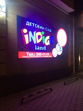
INDIGO LAND TASHKENT, ДОУ
356-400 Farobi ko'chasi, Тошкент
School
read more
1.649 km
Bright Education Centre
7b Kichik Xalqa Yo'li, Тошкент
School
read more
1.731 km
Shkola 11O
34 Gulobod Ko'chasi, Тошкент
School
read more
1.772 km
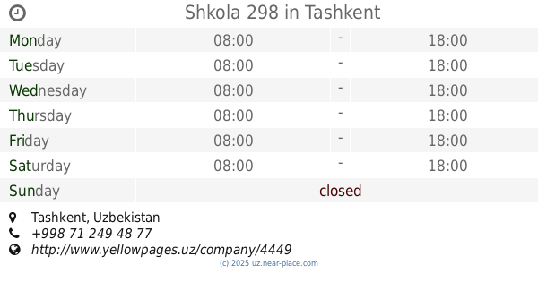
Shkola 298
Tashkent
School
read more
1.919 km
School #186
1 Orifon köchasi, Тошкент
School
read more
2.102 km
School 320
Tashkent
School
read more
2.289 km
PQQTMO markazi
4 Universitet Ko'chasi, Тошкент
School
read more
2.353 km
НОУ Smart Child
Алмазарский район, Тошкент
School
read more
2.441 km
Academic Lyceum
District, Almazar
School
read more
2.477 km
82 Shkola
Tashkent
School
read more
2.583 km
Rayono Shaykhantakhurskogo Rayona
улица Асадуллы Ходжаева, Тошкент
School
read more
2.792 km
Malaka Oshirish
Saidov Str., Тошкент
School
read more
2.804 km
Shkola Sekhriye
Saidov Str., Тошкент
School
read more
2.851 km
Olmazor politexnika kasb-hunar kolleji
Almazar
School
read more
2.919 km
School 262
Tashkent
School
read more
2.959 km
Shkola Orom
Khandamir Str., Тошкент
School
read more
3.344 km
Detskiy Dvorik
Kichik Xalqa Yo'li, Тошкент
School
read more
3.912 km
School 233
Taraqqiyot ko'chasi, Тошкент
School
read more
3.933 km
Chastnyy Detskiy Sad Aist
улица Аккурганская, 7, Тошкент
School
read more
📑
all categories
Accounting
Administrative area level 1
Administrative area level 2
Airport
Amusement park
Art gallery
Atm
Bakery
Bank
Bar
Beauty salon
Bicycle store
Book store
Bowling alley
Bus station
Cafe
Campground
Car dealer
Car rental
Car repair
Car wash
Cemetery
Church
City hall
Clothing store
Colloquial area
Convenience store
Courthouse
Dentist
Department store
Doctor
Electrician
Electronics store
Embassy
Establishment
Finance
Fire station
Florist
Food
Furniture store
Gas station
General contractor
Grocery or supermarket
Gym
Hair care
Hardware store
Health
Hindu Temple
Home goods store
Hospital
Insurance agency
Jewelry store
Laundry
Lawyer
Library
Liquor store
Local government office
Locality
Locksmith
Lodging
Meal delivery
Meal takeaway
Mosque
Movie theater
Moving company
Museum
Natural feature
Neighborhood
Night club
Park
Parking
Pet store
Pharmacy
Place of worship
Plumber
Point of interest
Police
Political
Post office
Premise
Real estate agency
Restaurant
Roofing contractor
Route
Rv park, camping
School
Shoe store
Shopping mall
Spa
Stadium
Storage
Store
Subway station
Supermarket
Synagogue
Taxi stand
Train station
Transit station
Travel agency
University
Veterinary care
Zoo
sublocality level 1
↑